Subscribe

Prolonged winter storm warning issued through Saturday

NWS says eastern part of metro region, including Camas-Washougal, could see another 3 to 9 inches of snow over the next 24 hours

By
timestamp icon
category icon Latest News, News, News
The Washington State Department of Transportation (WSDOT)'s traffic camera at Highway 14 and 164th Avenue outside Camas shows snowy conditions at 2:08 p.m. Friday, Feb. 12, 2021. The National Weather Service issued a prolonged winter storm warning for the area on Friday, Feb. 12, through 4 p.m. Saturday, Feb. 13, 2021. (Photo courtesy of WSDOT)

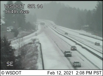
The National Weather Service has issued a prolonged winter storm warning alert for the greater Portland-Vancouver metro region through 4 p.m. Saturday, Feb. 13. 

While a mix of snow, sleet and freezing rain is forecast for the western parts of the region, the eastern half of the metro area, including Camas and Washougal, is forecast to have “mainly snow” over the next 24 hours. 

The NWS forecast shows the northern and eastern parts of the metro area could see an additional 3 to 9 inches of snow, with east winds gusting as high as 30 to 50 miles per hour in regions east of Interstate 205 and into the Columbia River Gorge. 

“Travel will be very challenging at times,” the NWS stated. “Power outages due to gusty winds and/or ice are possible. Be prepared for snow and ice on roadways.” 

The forecast calls for below-freezing temperatures to remain in the eastern part of the metro area through Sunday, Feb. 14. 

“If you must travel, keep an extra flashlight, food and water in your vehicle in case of emergency,” the NWS urged. 

To find the latest road conditions, call 511 or visit wsdot.com/traffic/vancouver/EastClark to view traffic cameras and see current road conditions in East Clark County. 

Closures include local schools, county’s mass vaccination clinic

The winter weather, which dumped at least 3 inches of snow throughout the metro area on Thursday and Friday, Feb. 11-12, has caused several closures. 

The Camas and Washougal school district both closed school buildings on Thursday, Feb. 11 and Friday, Feb. 12. 

Washougal School District Superintendent Mary Templeton announced a “snow day” with a funny song set to the tune of John Lennon’s “Imagine” on Thursday, Feb. 11. 

“Imagine all the people sleeping in today,” Templeton sings. “Imagine no assignments, synchronous or a-synch. No need to private chat today. No teacher screens to share. Imagine all the people … they’re sleeping in today.” 

“Please have a safe day,” Templeton adds at the end. “Students: do some homework and read a book.” 

To watch Templeton’s full performance, visit washougal.k12.wa.us/blog/2021/02/11/snow-day-2-11-2021.

The mass COVID-19 vaccination clinic at the Clark County Fairgrounds, as well as the COVID-19 testing site at Tower Mall in Vancouver, also closed on Friday, Feb. 12, and will remain closed on Saturday, Feb. 13. 

People who have pre-registered for testing at the Tower Mall site will be notified if their scheduled appointment is affected by the closures. Updates regarding the testing site closure are available online at ClarkCountyCOVIDtesting.org.

Those with an appointment for vaccination at the Fairgrounds site will be able to receive their vaccination next week, on Tuesday, Feb. 16. Staff at the mass vaccination site will honor first-dose appointments that were postponed due to the winter weather at anytime between 9 a.m. and 5 p.m. Tuesday, Feb. 16. For more information, visit doh.wa.gov/Emergencies/COVID19/VaccineInformation/MassVaccinationSites.

The city of Camas has posted its snow- and ice-removal map online, and said several local roads may be closed during inclement weather, including Northeast Dallas Street from Northeast Sixth Avenue to Northeast 14th Avenue; Division Street from Northeast Sixth Avenue to Northeast 11th Avenue; and Northwest Forest Home Road from Northwest 10th Avenue to Northwest Astor. For a full list of possible road closures, visit cityofcamas.us.

National Weather Service forecasts snow through Sunday afternoon

The NWS forecast calls for snow through Sunday afternoon, with temperatures beginning to rise — and rain returning — on Sunday, Feb. 14. 

Following is the NWS’ three-day forecast: 

Friday, Feb. 12: Snow likely, mainly after 4 p.m. Cloudy, with a high near 30. East wind around 16 mph, with gusts as high as 28 mph. Chance of precipitation is 60 percent. New snow accumulation of 1 to 2 inches possible.

Friday night: Snow. Low around 23. East wind around 17 mph, with gusts as high as 30 mph. Chance of precipitation is 90 percent. New snow accumulation of 3 to 5 inches possible.

Saturday, Feb. 13: Snow, mainly before 4 p.m. High near 30. East-Southeast wind between 9 and 11 mph. Chance of precipitation is 90 percent. New snow accumulation of 1 to 2 inches possible.

Saturday night: A 30 percent chance of snow, mainly after 4 a.m. Snow level at 500 feet. Mostly cloudy, with a low around 27. New snow accumulation of less than a half inch is possible.

Sunday, Feb. 14: A chance of rain and snow before 10 a.m., then a chance of snow between 10 and 11 a.m., then a chance of rain after 11 a.m. Cloudy, with a high near 37. Chance of precipitation is 50 percent. Little or no snow accumulation is expected.

Sunday night: Rain. Cloudy, with a low around 35.

For more information about the weather forecast, visit nws.noaa.gov