Subscribe

Camas seeks input on 20-year transportation plan

Public survey available on city's Engage Camas website

By
timestamp icon
category icon Latest News, News
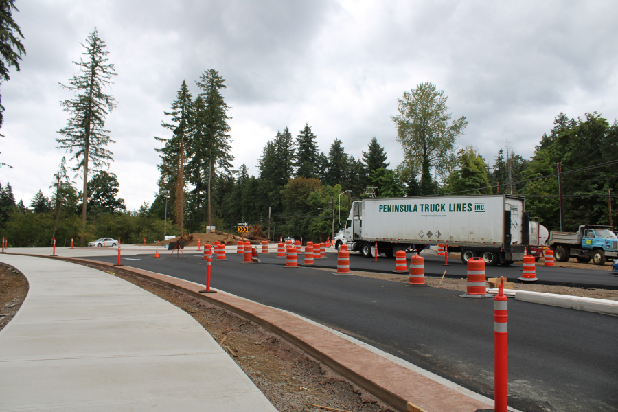
A truck travels through the partially completed roundabout at Everett Street and Lake Road in Camas on Aug. 21, 2020. (Kelly Moyer/Post-Record files)

Community members who want to help shape the future of transportation in the city of Camas — including road improvements but also bicycle lanes, pedestrian walkways and safer intersections — have a second chance to weigh in on the city’s 20-year Transportation System Plan (TSP) through the city’s Engage Camas website.

The city recently opened a second online survey to help city officials better understand the community’s priorities for the TSP, which will guide the city’s future transportation projects, help secure state and federal funding for local transportation needs and help calculate the city’s traffic impact fees.

The first survey, conducted in the fall of 2021, asked community members to share how easily they could walk, bike and ride public transit in Camas; tried to gauge how residents felt about traffic congestion on Camas’ streets; had survey participants rank their most important transportation issues as well as possible transportation improvement projects — from constructing new streets and widening roads to add vehicle capacity to adding cost-effective improvements that would encourage walking, biking and riding transit.

The second online Engage Camas TSP survey, available at engagecamas.com/transportation-system-plan, consists of eight questions including three open-ended questions about pedestrian and bicycle projects and “other transportation projects” that would support the city’s vision statement for 2040 painting Camas as a “safe, diverse and welcoming community” and “a livable place for people of all ages.”

Other survey questions are more pointed, asking residents if they support specific projects, such as lane reductions with bike lanes on certain roadways, and to rank their top five driving projects from a list of 13 possibilities that would widen or reconfigure certain streets to three-lane roadways with bike lanes or shared-use paths.

Plan continues after pandemic disruptions

Camas Engineering Manager James Carothers discussed the 20-year transportation plan with Camas City Council members in October 2021, and noted then that the COVID-19 pandemic had stymied the city’s work on the plan, which will produce a list of — and possible funding sources for — 20 years’ worth of city transportation projects.

City staff, along with consultants from DKS Associates, were working on the TSP when the COVID-19 pandemic began and many of the city’s general-fund projects were put on hold.

In 2021, Carothers said, city staff “slowed the progress on remaining (TSP) tasks in order to gather public comments on this plan.”

“Staff wants to be sure to include public engagement prior to presenting a TIF draft to Council,” Carothers told the city council members in October 2021, adding that city staff hoped to bring the plan to the Council in mid-2022 for adoption, but needed to “be sure all interested parties are heard before wrapping up the process.”

2019 transportation report highlighted commuter needs, safety issues

In 2019, DKS Associates, the city’s TSP consultants, completed an “existing conditions report” on the city of Camas’ transportation system.

This report found that “much of the traffic in Camas, especially during the more congested weekday peak periods, is related to employment” and that nearly 90 percent of workers living in Camas commute to a job outside the city — with more than 25 percent commuting to jobs in Oregon (Portland, Beaverton, Hillsboro and Gresham) that are at least 15 miles away from Camas. The report also found that 83 percent of people who work in Camas live outside the city.

The 2019 existing conditions report also showed:

  • There were 880 crashes on Camas roadways between January 2013 and January 2018. The majority (88%) of these crashes resulted in no injuries or minor injuries; 20 crashes resulted in serious injuries; eight crashes were fatal; 2% of the crashes involved a pedestrian and 1% involved a bicyclist.
  • The five most common driver errors — responsible for 60% of crashes in Camas between 2013 and 2018 — were inattention (29%), not yielding to right-of-way (13%), following too closely (10%), disregarding traffic signals or stop signs (3%) and operating defective equipment (3%).
  • Drivers who were under the influence of drugs or alcohol contributed to 79 crashes during this time period and included seven serious-injury crashes.
  • Speeding was a factor in 14% of all crashes in Camas between 2013 and 2018, and led to three deaths.
  • Most of the pedestrian-related crashes occurred in downtown Camas and along Northeast Third Avenue between Northeast Fourth and Northeast Weir streets. The majority of crashes involving a bicyclist occurred at intersections during the daytime, with the majority (58%) involving a driver who failed to yield the right-of-way to a bicyclist when turning.
  • The Camas intersections with the highest crash rates between 2013 and 2018 included N.E. 13th Street at N.W. Friberg-Strunk Street; N.E. Ingle Road at N.E. 28th Street-Goodwin Road (where five of 15 reported crashes resulted in injuries); N.E. 232nd Avenue at N.E. 28th Street; N.E. 199th Avenue at N.E. 58th Street; state Route 500 at N.E. Third Street; N.W. Sierra Drive at N.W. 28th Avenue; N.E. Sixth Avenue to N.E. Garfield Street; N.E. Third Avenue at N.E. Garfield Street (where there were two pedestrian-involved crashes); N.E. Third Avenue at N.E. Dallas Street (where more than one-fourth of crashes involved injuries); and S.E. 283rd Avenue at S.E. 23rd Street.
  • Four Camas intersections — Pacific Rim Boulevard at Payne Road; N.E. Sixth Avenue at N.E. Division Street; N.W. Sixth Avenue at Drake Street; and N.W. Sixth Avenue at N.W. Ivy Street – have high rates of traffic congestion during the peak p.m. hour.
  • The majority of Camas residents who use public transit live more than one-half mile from a bus stop.
  • About 75% of the roadways in Camas have pavement that is in good or satisfactory condition.
  • Seven of Camas’ bridges were flagged in the report as being “functionally obsolete,” including the bridge over Highway 14 on S.W. Sixth Avenue; the bridges over the Washougal River on state Route 500 and N.E. Third Avenue; the bridge over Lacamas Lake along state Route 500; the bridge over Lacamas Creek on N.E. Goodwin Road; and the bridges over the mill ditch on Division and N.E. Dallas streets.