Subscribe

Summiting Silver Star

Local hike offers breathtaking views of our region

By
timestamp icon
category icon Sports
A couple takes in the breathtaking view after a strenuous hike to the top of Silver Star Mountain.

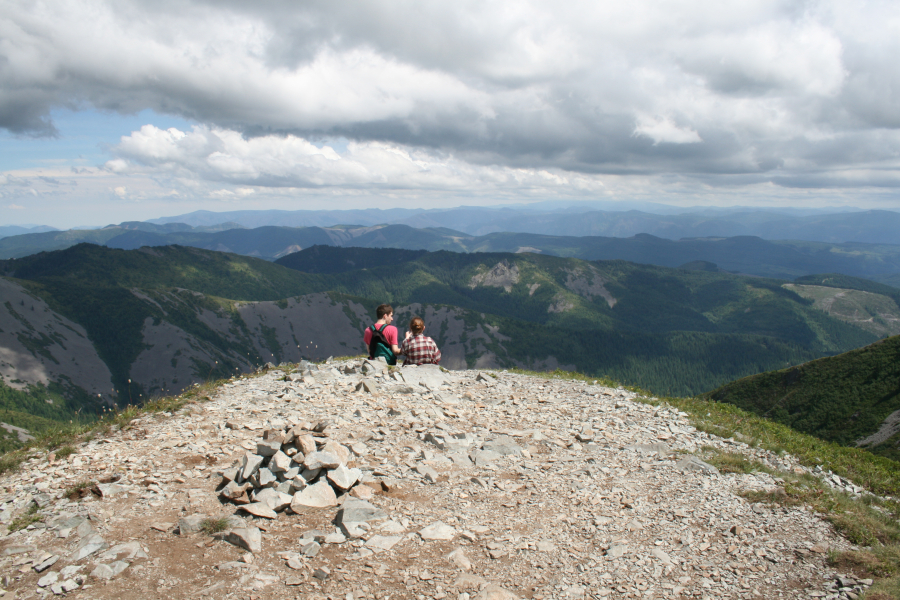
If you’ve never hiked to the top of Silver Star Mountain, you’re missing what is perhaps the single best view in the Camas-Washougal area.

On a clear day you can see five volcanoes: Rainier, St. Helens, Adams, Hood and Jefferson. The cities of Washougal, Camas, Vancouver and Portland and even the blue waters of the Pacific Ocean are visible from the 4,364-foot-tall extinct volcano that sits in our backyard, just north of Camas and Washougal.

Getting to the Skamania County mountain summit, however, is not for the faint of heart.

There are several trails that reach the bald Silver Star summit, but the closest trailhead to Camas-Washougal is Grouse Vista, which can be accessed by forest service roads above Livingston Mountain in Camas or Bare Prairie in Washougal. While the drive is easier to Grouse Vista compared to the Silver Star trailhead south of Yacolt, the hike up to the summit is longer and steeper. The round-trip journey is about seven miles long, but that includes a 2,040-foot climb to reach the spectacular mountaintop.

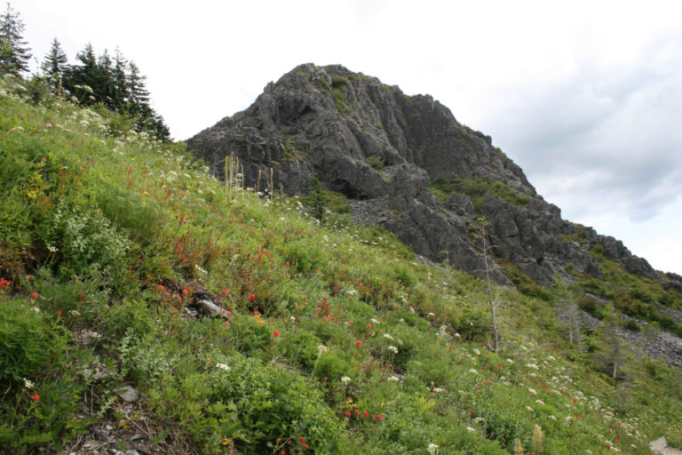
Trail starts out rocky and steep

The journey starts with a steep path winding its way through a heavily wooded forest. The path is covered in large, loose rocks, so good boots and trekking poles will save your day.

This steep trailhead is where I met Tanner Hampton of Portland, who was enjoying a day off from his office job. Hampton said he usually hikes in the Columbia River Gorge, but with so many of the Oregon gorge trails closed after the 2017 Eagle Creek Fire, he’s now exploring other regional hiking opportunities.

“This is the first time I’ve done this one, and I really like it because it’s really difficult,” Hampton said.

The first mile is indeed a tough climb. But then the trail breaks out of the forest into a massive open meadow dotted with wildflowers.

From here, you can see Vancouver to the west. On the non-view side of the trail, keep an eye out for unique geological formations, including Pyramid Rock and Sturgeon Rock. There are natural caves and even an arch formation near this part of the trail.

Suzie Nakashima and Ray Young, both of Camas, were returning from the Summit during this part of our trek and stopped to share some insights about the trail.

“We did this twice last year. I love the payoff at the top, but don’t like the hike up here. It’s pretty hard, steep and (has) lots of rocks,” Young said.

Nakashima said she enjoys the entire hike, which is why the two have found themselves on the trail twice in the past year.

“This time of year it’s so beautiful with the wildflowers. They are blooming everywhere,” Nakashima said. “Then, at the top — wow, the top! It’s such a big payoff.”

Hard work leads to big payoff

After the wildflower meadow, the trail ducks back into the trees and gets steep again.

Eventually, you will run into an unmarked trail junction from a separate trailhead. All you really need to know is: just keep climbing. That’s because, in about one-half mile, there is going to be a big reward for all your hard work.

The trail ends in the middle of a saddle on the Silver Star ridgeline. It’s worth checking out both ends of the saddle for a 365-degree view of pretty much everything you can imagine in Southwest Washington and Northwest Oregon.

While enjoying lunch on the cracked concrete foundation of a long-gone lookout tower, I got into a conversation with 67-year-old Jeff Booth, who was also resting for lunch after summiting the mountain for the very first time.

When I asked Booth where he lived, he just pointed toward Portland and said: “I know my home is right there, because I can see this peak from my front porch on clear days.”

Booth had extra weight in a large pack and was using the steep hike to train for an upcoming 150-mile backwoods journey in the North Cascades that will take him several weeks to complete. Having retired seven years ago from his information technology job with Metro in Portland, Booth now focuses his energy on hiking and caring for our nation’s longest trail as a volunteer for the Pacific Crest Trail Association.

“I’ve hiked a lot on the Pacific Crest Trail. In the ’70s, I attempted the trip from Canada to Mexico, but didn’t quite make it,” Booth said. “I’ve hiked all of Washington and Oregon twice.”

It pays to go slow on the hike down from the Silver Star summit, because there are so many loose rocks along the way.

The entire round-trip journey took about four hours, which included many stops along the way.

It’s a breathtaking journey to a view you will never forget and most likely, will be eager to repeat.

Photo