Subscribe

Jemtegaard trail threatened by erosion

City of Washougal put up fencin, signs asking people to stay on asphalt path

By
timestamp icon
category icon Latest News, Life, News
A 40-foot section of the Gibbons Creek bank lost 2 feet due to erosion over the past year, as shown in September 2023. (Contributed photo courtesy city of Washougal)

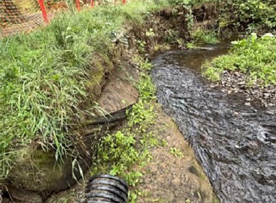
Less than three years after it opened for public use, Washougal’s Jemtegaard Trail is being threatened by “significant erosion” of the Gibbons Creek bank.

The City has agreed to a contract with Portland-based PBS Engineering and Environmental Inc. to repair the bank for $69,854, public works director Trevor Evers said during the Washougal City Council’s workshop session on Monday. Oct. 9. The Council will vote to approve the contract on Monday, Oct. 23.

“I think it’s a very important trail, especially for students,” Washougal Mayor David Stuebe told the Post-Record on Thursday, Oct. 12. “I would like to be able to see that (situation) rectified, but we have to do it the right way, and sometimes it costs a little bit of money, but in the long term, (it might) be best for the city.”

Evers said that heavy winter and spring flows have eroded a 40-foot section of the trail bank along the trail, compromising trail structure, and that if left unrepaired, further erosion could undermine the path, present a public safety emergency and jeopardize federal grant funding.

“We have some conditions that have changed significantly out there,” Evers said during the workshop session. “Gibbons Creek is constantly evolving, changing and moving. There’s a pinch point, or a hotspot, and since 2020, heavy bed load and transport contributed to a shift and change from (the creek’s) historical pattern for flows. About two feet of the bank was lost (last) winter, so we’ve removed (a clogged dispersion trench) out there to alleviate overbank flooding.”

The trail is open and currently does not pose a danger to users, according to Evers.

“We do not anticipate the trail posing a safety issue currently,” he told the Post-Record. “We have scheduled to conduct inspections during and after heavy rain events to ensure that the field conditions have not changed.”

The City has installed construction fencing on one section of the bank to notify pedestrians and cyclists to stay on the asphalt trail, Evers said.

“Potentially, in the future, Gibbons Creek could continue to erode and eventually compromise the creek bank and asphalt path,” he told The Post-Record. “We will continue to monitor to ensure trail users are navigating a safe trail while we work to design and permit the proposed trail improvements.”

The City contracted with Harper Houf Peterson Righellis, a Portland/Vancouver-based engineering firm, to provide project management and administration services, surveys, stormwater analysis, preliminary design and permitting, and preparation of final construction plans for the trail in 2013.

The trail, which links Jemtegaard Middle and Columbia Gorge Elementary schools to Sunset View Road, where it becomes a sidewalk that connects to the Sunset Ridge neighborhood, was completed in April 2021. The path includes a small bridge and is fully lit, with a pedestrian-activated flashing beacon at the intersection of Sunset View Road and Sunset Ridge Drive.

“This is a positive thing for our middle school students who should be able to use the path and have a modest walk or easy bike ride to get to school from many more neighborhoods,” Jemtegaard Middle School principal David Cooke told the Post-Record in 2020. “It’s great for kids to get more outdoor activity, and I’m supportive of the community partnership that’s creating this new way for students to get to school safely. I’m hopeful that the new, safer route will let more students walk or bike, both to get to school as well as to participate in athletics and activities that take place here.”

The original trail design showed “ordinary high water” 20 feet away from the trail infrastructure, according to Evers.

“We ventured (out) on this project I think almost eight years ago. It’s been challenging,” he said during the workshop session. “I have had conversations with our city attorney (about) any type of scenario where this would be a strong case as far as errors and omissions from previous design. (However), we don’t feel, given the current circumstances and the changing of creek patterns, that that would be a viable option.”

Evers declined to comment when asked by the Post-Record if Harper Houf Peterson Righellis could’ve anticipated the impact of erosion while designing the trail. Stuebe said that while it’s “hard to control Mother Nature,” he wants to ensure that the City makes every effort to “not repeat the same mistake.”

“That happened at Steamboat Landing — we had problems there, and we had to put more money back into it trying to fix it. Could that have been anticipated? Could (the situation with the trail) have been anticipated? I don’t know. But I think now we have to realize that, ‘This is what we built, and in two years this is what happened with erosion.’ Do we need to change the route or something? We can probably throw a ton of money into that bank, but is that really going to stop (the problem long-term)?”

Stuebe added that he doesn’t “want to just throw good money after bad money (and watch the) situation continue.”

“We’ll see if we can prevent some of that (erosion). If not, we’ll come up with a Plan B,” he said. “Again, it’s about spending ‘smart money.’ I’d hate to repair (the creek bank), then have it wash away during the next (significant) rainstorm. We don’t want to waste money. We don’t have that much to spend. You never want to take a step backwards. That’s why you want to do it right the first time. That’s why it’s really important to have the right people around the table to make it happen.”