Camas-Washougal logo tag

Washougal officials mull land use maps that will dictate city’s growth through 2045

Public open house set for 5 to 7 p.m. Wednesday, Feb. 26

By
timestamp icon
category icon Government, News, Washougal
The city of Washougal will hold an open house on Wednesday, Feb. 26, at the Washougal Community Center to present information about its two land use alternative proposals (Alternative 1 map pictured above) to residents. (Graphic contributed by the city of Washougal)

The Washougal City Council will soon select a land use map that will set the stage for the city’s growth over the next two decades.

The city of Washougal will hold an open house from 5 to 7 p.m. Wednesday, Feb. 26 at the Washougal Community Center to give more information about the two proposed maps under consideration. City council members are tentatively scheduled to select their preferred map during the council’s April 14 meeting.

“We’re not expanding our boundaries,” Washougal Community Development Director Mitch Kneipp said during a council workshop Jan. 31. “We’re not looking to make big, huge land grabs.”

Council members had reviewed the land use maps during their Jan. 31 and Feb. 12 workshops. The maps are part of the city’s comprehensive plan, which Washougal officials must adopt by the end of 2025 to satisfy a Washington State Growth Management Act mandate.

According to a city staff report, the chosen land use map and its policies will “reflect where and how” the city of Washougal grows over the next 20 years and will guide the creation of other city policies, including a capital facilities plan.

Kneipp and Jessica Herceg, a senior planner for DOWL, a Vancouver-based consultant firm, presented two land use map options to the city council Jan. 31. Both included an expansion in the city’s northeast urban growth boundary to accommodate the Washougal School District’s site-specific request. The school district later withdrew its request to include a 30-acre site in Washougal’s urban growth area after community questions and an environmental report convinced school district officials that the property was not appropriate for a future school site.

According to a staff report, without the school district’s request, “there are no UGB (urban growth boundary) expansions within the city of Washougal’s 2025-45 comprehensive plan update.”

City considers new housing requirements

Both of the updated land use maps take into account Washougal’s requirement to plan for the addition of 6,724 new residents and 3,735 new housing units by 2045. The city’s updated policies also will need to include ways to create more housing for lower- and middle-income earners, and will meet a new state law allowing up to two accessory dwelling units per residential lot, according to the staff report.

By 2045, the city must plan for 24,874 residents, an increase of 6,724 people; 3,735 new housing units, 1,961 of which must go to residents who earn less than 80 percent of area median income of $94,400; and 2,961 new jobs.

City leaders will consider regulatory changes, rezoning, urban growth boundary expansions and incentives to accommodate the growth, according to the staff report.

“The city is only going to grow north,” Herceg, a former Washougal city planner, told Washougal officials earlier this month. “We don’t have the ability to grow west or east or south. Thinking 20 years out, you’re going to have to, at some point, find another place for small hubs because it’s just not efficient to have everybody come down to ‘E’ Street or to Evergreen for their services.”

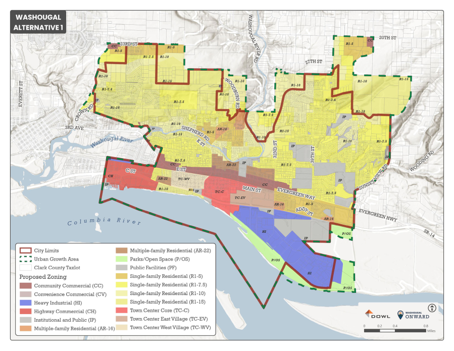
The map known as “Alternative 1” implements the northeast and northwest urban growth boundary subarea zoning; adjusts zoning on Port of Camas-Washougal property to reflect the new levee alignment at Steigerwald Lake National Wildlife Refuge; allows for multifamily housing in the commercial and town center districts; and will allow for more affordable housing, including ADUs, in the city’s residential areas, adding approximately 1,622 new jobs and 5,998 new housing units, 40 percent of which will go to residents who earn less than 80 percent of the area’s median income.

“We really don’t have much buildable AR-16 land in our current maps — land that is specifically designed for that multifamily residential product,” Herceg said. “In Alternative 1, we’re relying on that product to be developed in the town center and commercial districts, which can come with a trade-off of potentially losing capacity for jobs, and it sometimes results in a mixed-use product that isn’t quite what we envision it to be in the town center or along our commercial district.”

The map known as “Alternative 2” proposes changing the zoning in the city’s northeast urban growth boundary to increase land for commercial use and to add multifamily residential land; adjusts zoning on port-owned land to reflect the new levee alignment; adds less multifamily housing in the city’s commercial and town center districts; and would increase affordable “middle housing” and ADUs in residential zones. The “Alternative 2” options would add approximately 2,007 new jobs and 6,484 new housing units, 34 percent of which would be affordable for residents who earn less than 80 percent of the area’s median income.

“That northeast section of the city is where you’ll see a little bit more of a hub, for lack of a better word, kind of a little residential node, a slightly larger commercial area, and a little higher density of residential zoning,” Herceg said. “This particular plan, because we are planning for more density in the northeast, gives us a bit of an opportunity to put a little less of a burden on high density residential in our core and in our town center.”

Get the latest headlines in your email every week!

This field is for validation purposes and should be left unchanged.

Kneipp said the most difficult part of the planning process is accommodating housing that will meet a variety of income levels.

“Alternative 2 gives us a better shot at that,” Kneipp said.

Washougal City Manager David Scott said the Alternative 1 map offers a “little less” density, but the city will still be more dense than it is today.

“No matter what, it’s going to be denser,” Scott told city officials Feb. 13. “Future development will be denser than current development except in the (agricultural and rural-residential) zones. That’s our mandate, and we have to accommodate it.”